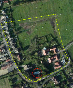
 The moat and the broader ditched enclosure did not originally start as a standard churchyard boundary. Instead, it marks the site of an early high-status manorial complex or an Anglo-Saxon minster. The yellow dotted line shows the enclosure boundary and the red circle, St Bartholomew’s.
The Lord’s Compound: In the Late Saxon and early Norman periods (10th–12th centuries), local lords or monastic groups built their primary residences, barns, and private chapels inside protected, earthwork enclosures or moats.
The Open Field Preservation (two field system): While the surrounding village layout shifted into tightly clustered medieval tenements, this specific enclosure remained relatively unchanged as open fields for centuries, preserving the ancient ditch profile.
The off-centre, corner placement of St Bartholomew’s within its own rectangular moat is a classic telltale sign of an evolving manorial layout.
The Lord’s Domain vs. The Rest of Us, when a private manorial chapel was first built inside a lord’s compound, the lord’s grand house (the hall) typically took up the prominent centre or north side of the enclosure. The chapel was built near the perimeter wall or corner. This allowed the local villagers to access the church for services from the outside without walking directly through the lord’s private domestic living space.
Separation of Space, placing the church in the southwest corner meant the main gates could face the exterior village tracks, while the rest of the moated island remained secure, private, and reserved for agricultural or residential use by the estate owner.
 Covenham was staggeringly wealthy for a settlement of its size. When the Normans later compiled the Domesday Book in 1086, Covenham ranked in the top 20% of all recorded English settlements for wealth. This wealth was established long before 1066 due to a vital coastal resource: Salt.
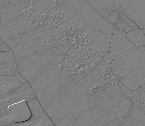
A lidar map showing salt workings along the medieval shoreline with Covenham reservoir (bottom left) for reference.
Before the Norman invasion completely disrupted the village, the Domesday Book records that the land at Covenham was held by a wealthy Saxon freeman/then named Esbjorn. Esbjorn ran a bustling estate worked by scores of Saxon villagers (villains) and free tenants (sokemen).
The estate featured heavy agricultural output, boasting multiple multi ox plough teams and 60 acres of valuable meadowland.
 A bitter point of frustration for local residents and historians is that this loss was entirely preventable.
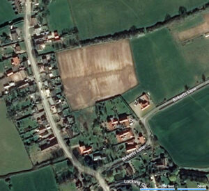
Image of the destruction to the site, post the moat being back filled and the site levelled, removing all surface archeaology.